
Landscape Mobile 4
Use the Landscape mobile app to collect data in the field. Data collected with the mobile app syncs back to the web app, where you will use it to create reports and document your organization's activity on each Portfolio Record.
This article covers the basic functionality of Landscape Mobile 4. You will find links to other relevant articles throughout and at the end. For a video walkthrough of the app, check out this article.
Jump to...
Searching for Portfolio Records
Search for "Landscape Mobile 4" in the Apple App Store or Google Play Store to download the app.
Menu
Tap the 'hamburger' menu to view your username, Switch Organizations, or Sign Out. The Menu is also where you control in-app Settings.
When you're ready to leave the Menu, tap the X icon in the top right corner.
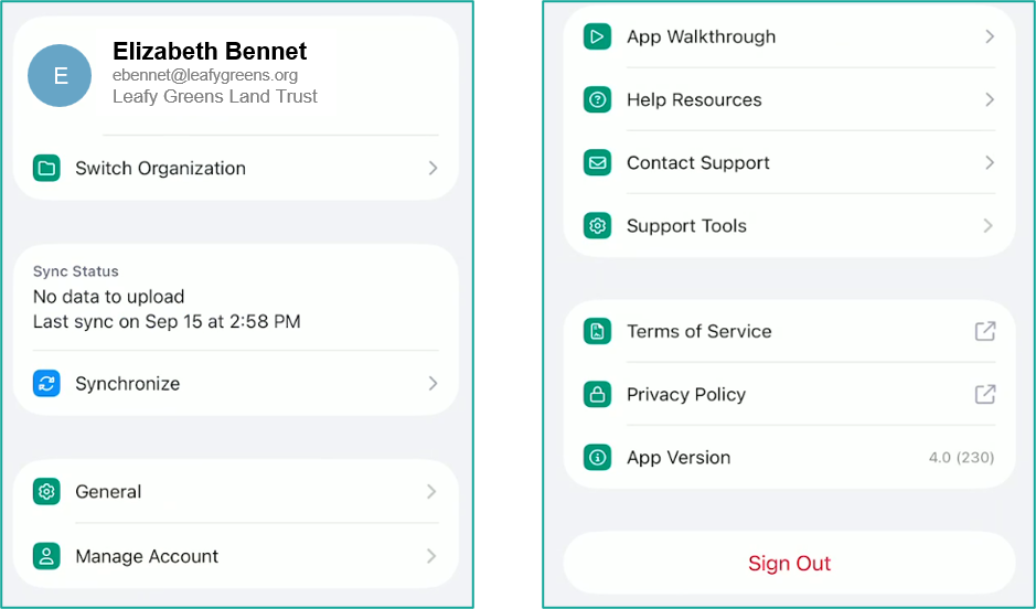
| Menu Item Name | Available Actions | Description |
|---|---|---|
| Switch Account | Select from a list | If your email address is associated with a User in more than one Landscape account, tap here to switch between organizations. |
| Synchronize | Push an immediate sync to the web app. | Synchronization happens any time you open the app (including switching between apps), or by tapping this menu item. Internet connectivity is required for synchronization to happen. |
| General | Appearance | Select from Same as Device, Light, or Dark modes. |
|
|
Smooth GPS Tracking | When toggled ON, this setting filters out erratic coordinate points to create a cleaner, more continuous route of your path when recording your location. When toggle OFF, the app will store every location point collected by the GPS. |
|
|
Sync on Mobile Data | This setting doesn't control whether your data syncs — only how. When toggled ON, this setting uses your cellular data to synchronize the data you're collecting in the mobile app to the web app. When toggled OFF, the app will only sync when you are connected to WiFi. |
|
|
Include Photo Uploads | When toggled ON, this setting uses your cellular data to upload photos to the web app during synchronization. When toggled OFF, your photos will not be synchronized to the web app until you sync while connected to WiFi. |
| Manage Account | Delete account | Sends a request to Support to delete your entire organization's account. |
| App Walkthrough | Opens a short app tutorial | If this is your first time using the app, or you need a refresher, this quick tutorial walks you through basic app functionality. |
| Help Resources | Opens the Landscape Knowledge Base | Browse for how-to or troubleshooting articles that may be relevant to your fieldwork. |
| Contact Support | Opens a web form for you to submit a support ticket | If you can't find what you're looking for in the Knowledge Base or need additional help, send an email to Support. |
| Support Tools | Send GPS Logs | Files that can be exported and shared with Support in the event your trackline does not synchronize with the web app. Please reach out to Support first if you need help with your GPS logs. Support will not acknowledge logs that are sent without an accompanying support ticket. |
|
|
Send Error Logs | Files containing data about data synchronization errors which can be shared with Support. Please reach out to Support first if you need help with your error logs. Support will not acknowledge logs that are sent without an accompanying support ticket. |
|
|
Reset All Data | This will delete all local data from the app — including unsynced work and downloaded records — and retrieve the latest data from the web server. |
| Terms of Service | Opens our Terms of Service webpage on your device's default browser |
|
| Privacy Policy | Opens our Privacy Policy webpage on your device's default browser |
|
| App Version | — | Displays the release version of the mobile app installed on your device. |
| Sign Out | Log out of the app |
|
If you don't want the app to use any data for synchronization, toggle Sync on Mobile Data OFF.
Map Layers
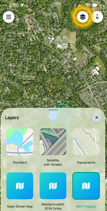
On the main screen, tap on the map layers icon in the top right corner to add contextual data to the map. When no record is selected, you will only have the option to change basemaps. Once you have selected a record, you will also have the ability to turn on overlays.
- Select a different Basemap from the list that your organization has added to your account via custom layers.
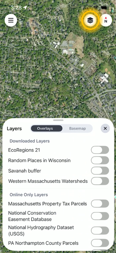
- Overlays can be toggled on or off. These include:
- The Portfolio Record's General and Related [Record] General layers
- All Record Boundaries (previously "Nearby Boundaries") and Sub-Record Boundaries
- Any Custom Layer that your organization has added to your account. These are separated into lists of Downloaded (imported) layers and Online Only (linked service) layers
Service layers and Lens Imagery layers will only be shown if your device has network connection. They cannot be downloaded for offline use.
An Administrator must first add custom map layers in the web app for them to appear in the mobile app. Read more about adding custom layers HERE.
Searching for Portfolio Records
There are two ways to locate Portfolio Records in the mobile app: searching a list or moving around the map. When you have located the Portfolio Record you need, tap its name to select and interact with that record.
The Portfolio Records you are able to see in the mobile app are controlled by the permissions assigned to you in the in the web app. Read more about configuring permissions, HERE.
Search a list
The Search and Filter tray begins in a minimized state on the main app screen. Use the search bar to type the name of a record, or select one or more of the built-in filters to automatically narrow the results.
Browse and interact with the filters by swiping to the right, or tap All to display and interact with all available filters.
Searching by name and applying filters will narrow the results you see both in the record list and on the map.
- Downloads displays a list of all Portfolio Records that you have prepared for offline use. Remove downloaded records by tapping the trash can icon.
- Filter by Portfolio-specific attributes like Status, Interests, Stewardship Site, and/or Record Type.
- Filter by My Records to see only those records where you have been assigned as the Lead or to the Team.

Move the map
In the map view, each record's name is displayed as a map label.
The map will automatically zoom in to your location when you open the mobile app. Pinch and swipe on the map view to zoom in or out, or to pan in different directions to find a Portfolio Record.
Tap the compass icon in the top right corner to toggle your orientation between north-facing and directional.

If you can't find the Portfolio Record you are looking for, review THIS ARTICLE for a list of common causes and troubleshooting steps.
TIP: Tap and hold anywhere on the map to navigate to that spot using your device's default mapping application.
Navigating a Portfolio Record
Once you've selected a record, you can view, add, and edit information about them according to your permissions. Use different basemaps or custom layers to provide geographical context to your fieldwork.
The types of data you are able to see and/or edit in the mobile app are controlled by the permissions assigned to you in the in the web app. Read more about configuring permissions, HERE.
Work
Tap the + Add Work button to skip the work list and quickly create one of the following Work Items:
|
Site Visit |
Human Use |
|
Issue |
Tracked Right Activity |
|
Species Observation |
Encumbrance |
|
Resource |
|
Tap the Work icon to view the entire list of Work Items in this Portfolio Record and to toggle Work Item geography on or off in the map.
- Sort the list by Date modified, Date created, or Work date.
- Search the list by Work Item Name.
- Filter the list for certain categories, or expand a category to filter only for certain Types.
- Tap Show/Hide all map layers to toggle the geography on/off for all Work Items. Tap the map layers button next to any individual Work Item to toggle just that item's geography on or off.
- Tap on either the Work Item's name or its visible geography to open it.
When Show all map layers is selected, you will also see a filter appear in the top left of the list for [#] visible map layers. Tap this button to filter the Work Item list to only the items that have visible geography.

BUT WAIT - THERE'S MORE!
Work Item functionality has been significantly expanded in Landscape Mobile 4 and has its own Knowledge Base article, HERE.
Download
Tap the Download button to temporarily store record data locally on your device so you don't need internet to access them ("offline use"). The download will include Work Item-related photos and any documents you've toggled for mobile availability; users will also have a choice of which map tiles to include for download (Standard, Satellite with Streets, and/or Topographic). An estimated total file size is displayed prior to confirming the download.
We recommend downloading any records for offline use while you're connected to WiFi, rather than using your cellular data.
Preparing a record for offline use is also part of the recommended monitoring workflow. Read more about monitoring with Landscape Mobile 4, HERE.
Details, Contacts, Notes, and Attachments
- Scroll down the Portfolio Record's main page to view that record's basic Details and a list of Related Records. Only Details fields that have been filled in from the web app will appear in the mobile app (e.g., if your Portfolio Record does not have anything in the 'Stewardship Description' field in the web app, you will not see that field at all in the mobile app.)
- Tap on Contacts to view the Portfolio Record's contact cards. Tap on a contact card to view or edit additional information like phone number and email. From the contact card, tap on the phone or email icons to complete relevant actions in your device's default app.
- Tap on Notes to view a list of Notes added at the Portfolio Record level. Pinned Notes are marked with a yellow thumbtack icon and also display at the top of the main Details page.
- Tap on Attachments to view a list of all files associated with this record (per your permissions). When you are connected to the internet, you will be able to open any item in this list. If you are offline and viewing a downloaded record, you will be able to open only those documents you selected for offline use. Attachments will open in a new tray in the app.

|

|

|