Create, import, export, edit, copy, and style map data (video and article)
From your property boundaries to your trails, Landscape allows you to map and manage nearly any aspect of your protected lands. However, mapping in Landscape is a bit different than mapping with a program like ArcGIS or QGIS. The most important difference is that mapping in Landscape is largely context dependent, meaning you can't simply upload or edit anything from any map. For example, if you want to edit site visit points, you have to first either create a site visit work item to house those points, or navigate to the site visit work item that already exists that you wish to edit. Likewise, if you want to import a property boundary, you first have to create a property record.
Importing Data
Landscape allows you to add map data in many different ways. You can import a shapefile, .kml or .kmz, .gpx (for line features), or even geotagged photos, which will be brought in as points. You can also simply draw a shape or drop a point on a map, or easily copy from other sources, including third party service layers like a parcel layer provided by your county, or other Landscape geography.
Exporting Data
Any map data that exists in Landscape can be exported as a shapefile or .kml either record by record or in bulk. Note that by using data viewer, you can customize the attribute table of your exported shapefile.
Custom Layers
For 'background' layers which need to exist outside of the specific context of a single portfolio record, you can use custom layers. Custom layers do not belong to any specific portfolio record or work item. Custom layers can be third party service layers like an ArcGIS Online Feature layer, in which case you set up a link between Landscape and that layer, or you can upload your own custom shapefile. Uploading custom shapefiles is only appropriate for smaller layers, as large layers (like parcel maps for entire regions) can bog down map performance. More on custom layers here.
Geography Attributes
Once you've added geography to a record or work item, you can edit its attributes. These fields can be seen by clicking on an object on a map. This is data that belongs specifically to that geography, rather than with the record or work item. In a typical GIS system, a shapefile can have as many attributes as needed. In Landscape, the attributes of all geography are fixed. In other words, if you are importing a shapefile, you cannot import the attribute table as well (with the exception of Landscape's fixed fields - see below). Instead of using custom attributes, Landscape allows you to use the rest of the data fields available to house information about that thing. For example, you no longer need a 'Landowner' attribute in your boundary polygon, since Landscape has actual contact records to house far more information than a 'Landowner' field.
The attributes available to all geography in Landscape are Name, Map Label, Map Item Status, Map Item Type, and Description. All of these are text fields, but status and type can only draw from options the user sets in Settings. Everything on a map also has geometric attributes which belong to that particular shape, like lat/long for a point, length for a line, and area & perimeter for polygons/areas.
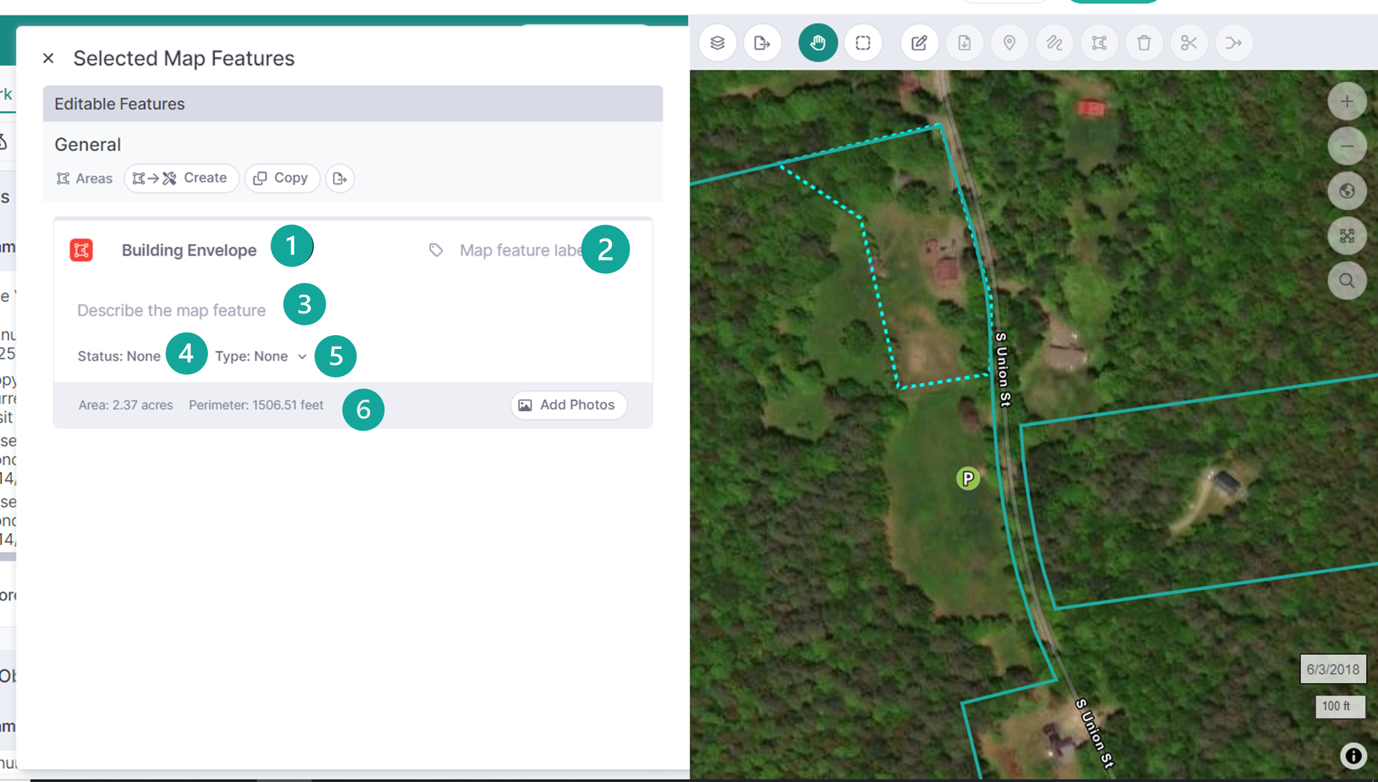
These Landscape geography attributes can be imported if the user is precise about naming the fields in the imported shapefile. The names of the fields must be (exact match): 'NAME', 'MAPLABEL', 'STATUS', 'TYPE', 'DESC' / 'DESCRIPT' (all lower-case field names are also supported).
Any point, line, or polygon can also contain one or more photos. These photo items have their own attributes of Description, Taken On (Date), Taken By, Direction (Degrees), and Status. Note that geography description and photo description are different - one describes the point on the map, the other describes the photograph. When you are using the mobile app and click 'Describe' to add a caption, you are editing the photo description.
When you import geotagged photos into a points layer, or take photos on the mobile app, the map points are automatically created to house the photos.